
![]()
We keep losing biodiversity!
The stark realities of the global climate and biodiversity crisis pose imminent global threats to biodiversity, ecosystems, and human lives and livelihoods. It is well established that land-use and land-use changes are major threats to biodiversity and ecosystem functioning and services. Science has developed a comprehensive scientific consensus knowledge-base on climate and environment, and we have reached important political consensus on environmental policy goals. Still, climate and environmental concerns more often than not are trumped by other societal interests, and thus the loss of biodiversity and ecosystems is still accelerating.
So, why are we failing to implement environmental policy goals effectively?
The mere existence of the data and knowledge is not enough, it must also be available. More specifically, data and knowledge must be available in formats and at spatial scales that are relevant to the local decision-makers holding the key to land-use transformation. However, the available ecological data often is spatially scattered and managers struggle to connect it to their local contexts. In addition, basic ecological information may be intangible for the systems and rules managers have to relate to and navigate. In both situations, existing environmental knowledge likely ends up being ignored, as it relates poorly to local cases and the decision-making processes.
What are we doing about this?
ECoMAP counters these challenges by
- collaborating with local and regional decision-makers to identify mismatches between available and sought-after information
- deriving ecological variables from existing raw ecological data that are of relevance for decision-making processes
- using modelling approaches to fill the gaps in spatial coverage of ecological information
- making the ecological information resulting from a-c) available as map-layers in the portal for ecological base maps at the Norwegian Biodiversity Information Centre
In order to achieve this, ECoMAP capitalizes on (i) improved understanding of the characteristics, variables and indicators of ecological condition, (ii) rapid growth in biodiversity data, remote sensing, and open science, as well as (iii) advances in ecoinformatics and modelling tools.
Natural History Museum, UiO
Work packages 3, 5
The activities in ECoMAP are organized into Work Packages, with WPs 2-4 focusing on modelling, WP 5 on the technical implementation with Ecological Base Maps, and WPs 1 & 6 on the stakeholder framing and practical application.
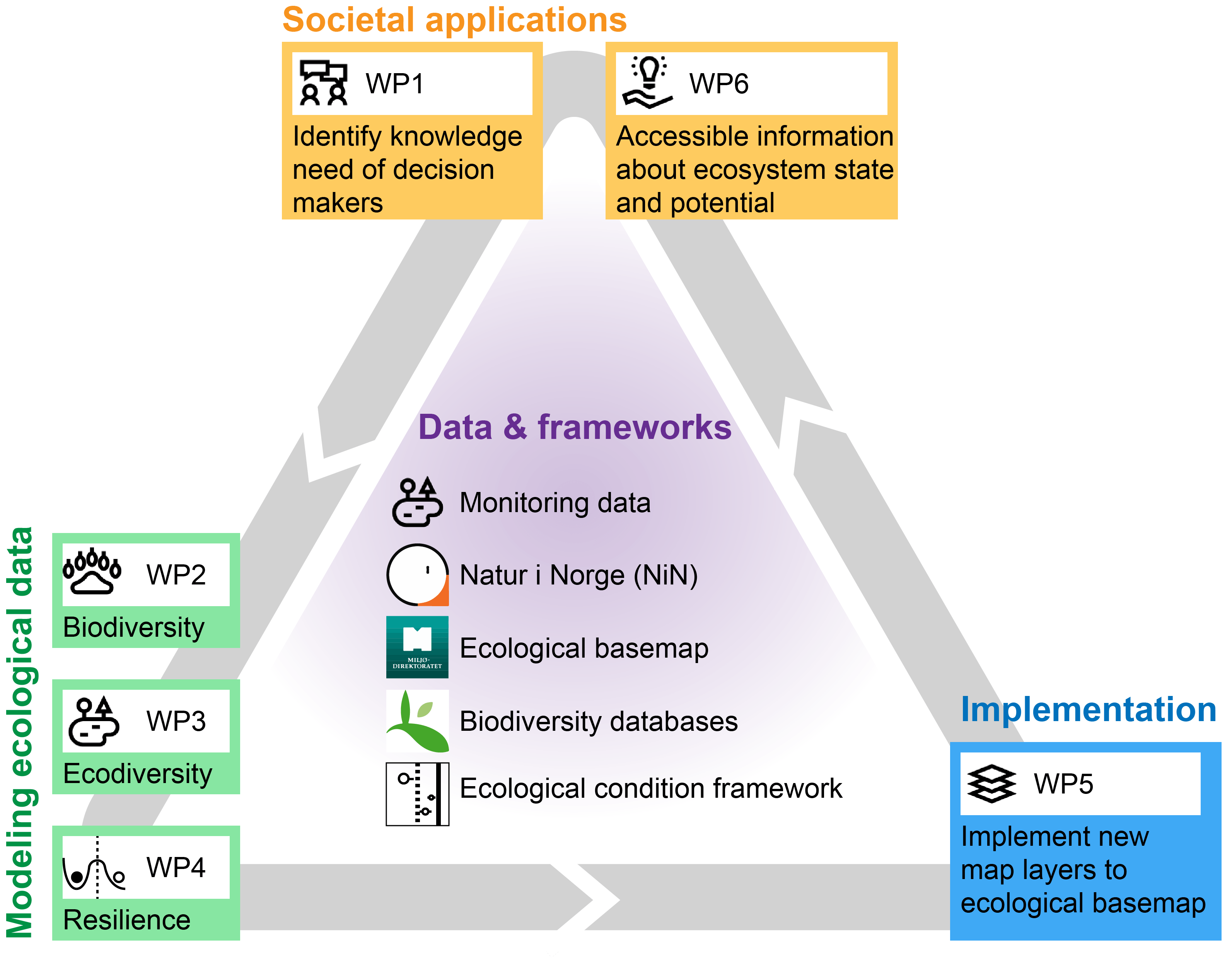 WP1
WP1
In WP1, we aim to develop a shared understanding across the science-policy interface of how we can enhance knowledge-based decision-making in nature management and spatial planning. This will involve two reference groups: The applications and users reference group will focus on the Norwegian context, and bring together stakeholders from (i) research (ii) national, regional, and local nature management authorities, (iii) road and energy sector, (iv) private sector, and (v) non-government organisations, and will produce a shortlist of potential variables of interest, across stakeholders, for mapping, which will be developed further in WP2-WP4. The international concepts and methodologies reference group will, together with key personnel from WPs 2-5, synthesise approaches with ecosystem assessments in Australia, EU Estonia, UK, and UN (see33).
The work in WP1 is led by Liv Guri Velle (Møreforsking) and includes all collaborating partners.
WP2
In WP2, we aim to improve and test methodologies for fine-resolution map layers of biodiversity-related variables. We will first model the domestic Norwegian distributions of terrestrial species (vascular plants, bryophytes, lichens, fungi, invertebrates, vertebrates) for which sufficient occurrence data are available, and predict probabilities of species occurrences for mainland Norway. From these models we will then derive a set of biodiversity metrics (informed form WP1) for generating biodiversity map layers in the ECoMAP tool.
We will develop novel species distribution models (SDMs) featuring key innovations on spatial random effects, regularization, and integrated observation models to ensure robust predictions. This will represent the first attempt to adequately incorporate all these innovations into a single analysis workflow, which necessitates a hierarchical modelling framework under Bayesian inference. In addition we will validate our model fits using a k-fold cross-validation approach, and ‘ground-truth’ the model predictions for a subset of species for which there exists structured survey data as a benchmark such as independent data sets from publicly funded, national monitoring schemes and studies on plants, insects, birds, and mammals (e.g. ANO, TOV, national bird monitoring, insect monitoring, …).
Based on these species distributions we can then collate species lists for any spot on the Norway map and from these lists derive biodiversity-related variables.
Importantly, the key output of WP2 is not simply a series of maps for each terrestrial species in NBIC, but a system that can automatically build these maps so that we can provide a dynamic baseline of species distribution estimates that are updated as new data is archived.
The work in WP2 is led by Joseph Chipperfield (NINA) and comprises partners from UiB, NIBIO and NINA.
WP3
In WP3, we aim to develop and apply methodologies for generating map layers of ecodiversity variables. We will model domestic distributions of ecosystem types and document ecosystem characteristics indicative of ecological condition, such as productivity and vertical vegetation structure.
For defining ecosystem types, we apply ‘Nature in Norway’, the national systematization framework for ecodiversity (NiN). Ecosystem distribution models (EDMs) primarily use climate, topography, geology, hydrology, land cover and landscape type variables to predict the occurrence probability of ecosystem types. We will expand the recently developed methodologies for EDMs by incorporating satellite remote sensing (RS) variables and LiDAR data. In addition to predictions of ecosystem distributions, this will produce satellite-derived indices of productivity and other ecosystem properties (NDVI, PAR, etc.), as well as vertical vegetation structure, covering the entire mainland Norway. Second, we will test the effect of combining satellite remote sensing mapping of ecosystem types with field based mapping of ecosystem types. Third, we will test the potential for using LiDAR data, e.g. ICESat-2 space laser data, providing e.g. high-resolution information on vertical vegetation structure, in combination with spectral satellite RS-data and other variables in distribution modelling of ecosystem types. Based on the modelled maps we can estimate a diverse set of derived landscape scale ecosystem metrics such as # of ecosystem types, # of red listed ecosystems, ecosystem type diversity, etc. at the resolution of individual grid cells or in given circular buffers surrounding each grid cell. As for SDMs there are issues with spatial errors, overfitting, and observation errors that have so far been disregarded in EDM development. We aim to infuse the recent developments from SDMs into EDMs by adapting the same techniques as in WP2 to the extent possible.
The work in WP3 is led by Rune Halvorsen (UiO) and comprises partners from NINA, UiB and UiO.
WP4
WP4 aims to develop a methodology for generating spatially explicit model estimates for ecological resilience based on output from the biodiversity and ecodiversity modelling in WPs 2&3.
Here, we will develop a suite of statistical tools which will enable us to quantify the shape of the resilience attractor basin for a given ecosystem state-variable in relation to climate and other ‘forcing’ variables. For this we need to develop of three sub-models:
- Ecosystem stable state location sub-model (How many stable states for a given ecosystem state variable in relation to different extrinsic drivers?)
- Ecosystem latitude sub-model. (What is the width of the attractor basin?)
- Ecosystem membership sub-model. (What is the probability of being in a specific attractor basin?)
Based on the statistically defined stable state number, location and width of the basin, we can calculate the probability of each data point being in a given stable state dependent upon the set of ecosystem forcing variables. Technically, we will apply multinomial regression models in a joint hierarchical Bayesian framework for the resilience modelling.
The work in WP4 is led by Alistair Seddon (UiB) and comprises partners from NINA and UiB.
WP5
WP5 aims to make biodiversity, ecodiversity, and resilience variables developed in WPs 2-4 permanently available to relevant stakeholders in Norway by integrating ECoMAP outcomes into the Ecological Base Map infrastructure at The Norwegian Biodiversity Information Center (NBIC). The ECoMAP outcomes will thus be openly accessible. A key feature of ECoMAP in this context is that the outcomes are dynamic: as more data accumulate, automated processes for data mining, modelling, and mapping will ensure updated map layers on the NBIC servers.
The work in WP5 is led by Joachim Töpper (NINA) in close cooperation with Øyvind Bønesrønning (NBIC) and includes all collaborating partners.
WP6
WP6 involves the reference groups (see WP1) in synthesis and communication of the knowledge gained from WPs 1-5.
WP6 will host workshop(s) for (i) dissemination of ECoMAP products and applications in the Ecological Base Maps as well as (ii) hands-on exploration of the data and map layers focusing on relevant cases from the participants’ regions and areas of interest. Feedback from these sessions will guide methodological development and communication of the outcomes. Internationally, we will benchmark ECoMAP against systems for ecological condition assessments like the UNs ecosystem accounting framework, and other variable mapping tools like the Estonian Rohemeeter (Greenmeter).
The work in WP6 is led by Vigdis Vandvik (UiB) and includes all collaborating partners.